Originally posted on 2021年6月6日 @ 上午6:11
此《Serindia》(西域考古图记)由英国探险家斯坦因著。全系列分为五卷,前三卷为调查报告(包含实地照片和勘测图),第四卷为图版(塑像、壁画、写本等),第五卷为地图。主要内容为记录 1906 至 1908 年斯坦因在中国新疆和甘肃西部地区进行考古调查和发掘的成果。此套英文本出版于 1921 年。
《西域考古图记》一书涉及的地域十分广阔,从西向东包括了今和田地区、阿克苏地区、巴音郭楞蒙古自治州、吐鲁番地区、哈密地区和河西走廊一带。在这些地区调查和发掘的重要遗址有阿克铁热克、喀达里克、麻扎塔格、尼雅、安迪尔等遗址,米兰佛寺遗址和吐蕃城堡遗址,楼兰古城及其附近遗址,焉耆明屋及其附近的石窟寺和遗址,甘肃西部汉长城和烽燧遗址,敦煌千佛洞和藏经洞等。斯坦因在这些遗址所发现遗物的主要类别有雕塑、绘画、简牍文书(包括汉文、梵文、和田文、龟兹文、吐蕃文、突厥文、粟特文和回鹘文等)、织物(丝、毛、麻、棉等)钱币、碑刻,佛经残卷,以及大量的陶、木、石、金属(金、银、铜、铁等)、玻璃、料器等质料的生活用品、生产工具、装饰品和兵器等。书中还配有大量遗迹插图,遗址平、剖面图,还有一卷遗物图版和一卷调查地区的地图,全书以考古学为核心,并基本上涵盖了前述诸多学术领域,内容十分丰富。
卷一:Main text No.1. Records history, ruins and excavated artefacts from various regions in the western region along the southern route from northwest India. Covers Khotan, Domoko, Niya, Endere, Charchan, Charkhlik. Lop desert, Kroraina (Loulan) and Miran.
记录了印度西北部南线沿线西部地区各地区的历史、遗址和出土文物。涵盖了霍丹、多莫科、尼雅、恩德雷、恰尔汗、恰克里克。洛普沙漠、克罗拉纳(楼兰)和米兰。
卷二:Main text No. 2. Refers to Dunhuang and details ruins of wall defenses, Mogao Caves and artifacts found in Cangjing caves.
记录了敦煌,并详细介绍了城墙防御遗址、莫高窟和藏经洞中发现的文物。
卷三:Main Text No.3. Records the history, temple ruins and fort ruins for various regions in west Kansu (Xian, Jiuquan Zhangye), the Northern route in the western region (Hami, Turfan, Kara-shahr, Kucha Maral Bashi, Khotan), and the southern route in the western region (Khotan).
记载了关西各地区(西安、酒泉张掖)、西域北线(哈密、吐鲁番、喀喇沙尔、库车马拉尔巴什、和田)、西域南线(和田)的历史、寺庙遗址和堡垒遗址。
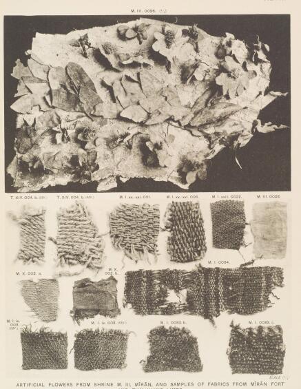
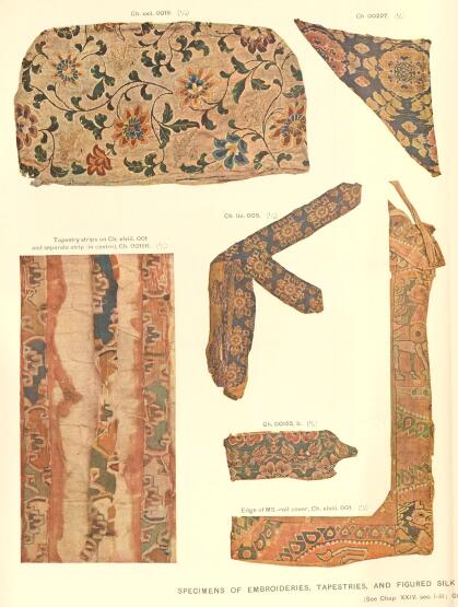
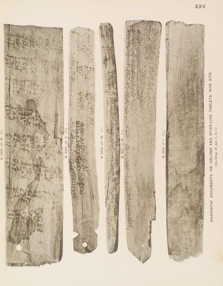
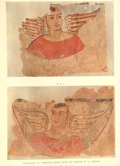
卷四:Paintings (total of 175 items) Terracotta fragments, wall painting fragments, seals, stucco statues, and ancient documents (Kharosthi documents and Brahmi script), Lifestyle items, wood carvings, currency, items from the Cangjing caves (Buddhist paintings, scrolls, died fabrics, documents written in various ancient scripts).
图版(共 175 幅)包含:陶俑残片、壁画残片、印章、灰泥塑像、古文献(佉卢文和梵文)、生活用品、木雕、货币、藏经洞的物品(佛画、卷轴、各种古文字书写的文献)。
卷五:Maps (total of 94 sheets). Maps showing only locations of archaeological interest in a wide area stretching from Kashgar in the West to Zhuangye in the East, from the Tārīm Basin to Kansu Province. The map covers from longitude 35° north to 44° north, and from latitude 75° east to 101° east.
地图(共 94 幅)。地图仅显示了西起喀什,东至张掖,从塔里木盆地到甘肃省的广大区域内具有考古价值的地点。地图覆盖范围为北纬 35 度至北纬 44 度,东经 75 度至东经 101 度。


| 语种:外文 | 格式:PDF |
| 编号:西域考古 | 大小:1.9G |
| 页数:5卷全 | 默认软件:Adobe Reader |


